March 30 2006 scout
Tuesday, March 28, 2006
Outer circum New River Watershed Test June 8th 2005
 TAP THIS FOR FULL MAP PDF!
The field data on this webpage is from oldest
to more current.

I just started this blog to list our testing
so I am finding our old tests results and am
 adding it to this page. To get current
results scroll down.


New River testing June 8th 2005

Notes:

All the results came from a Lamotte water testing kit
except for the drop kit. The drop kit is a liquid test
commonly used on aquariums to measure Ph. We started
at the southern part of the New River above the
Anderson county line on Hwy 116 which becomes the New
River Road. The car milege is to facilitate how many
miles the streams are apart. I have no idea what “CP”
s are but I wrote down the signs when I saw them.

We got samples from as close to the middle of the
streams as possible. We collected samples in plastic
water bottles and numbered the sample bottles. When
then took The bottles home and tested them with the
Lamotte kits.

TAP THIS TO VIEW STREAM TEST RESULTS 1-7
ZEB MOUNTAIN TEST RESULTS MAR 11 2006
pics and sum of this trip at
http://unitedmountaindefense.org/zebwatertesting.php
Hey here are the field sheets from our latest round of field testing of streams at Zeb Mountain (MTR site). Currently the samples are in the lab getting tested for some heavy metals. Will post the heavy metal results on our website.
http://unitedmountaindefense.org/zebwatertesting.php
Hey here are the field sheets from our latest round of field testing of streams at Zeb Mountain (MTR site). Currently the samples are in the lab getting tested for some heavy metals. Will post the heavy metal results on our website.
Sunday we are going to Bledsoe County to scout and test an area that has been designated as unsuitable for mining due to acid coal seams. Apparently the coal companies have logged it and are doing core samples to explore mining there.
We couldn't test 1/4 of the Zeb watershed cause our off road taurus couldn't handle it. If someone has an SUV or truck...
TAP THIS TO VIEW TEST RESULTS STREAMS 1-12
Monday, March 27, 2006
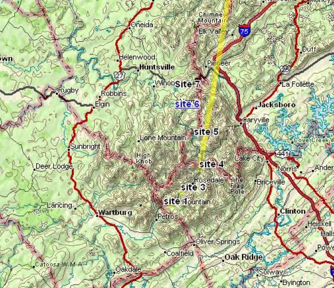
Field Sheet 1New River Watershed March 25 2006 PIC 7
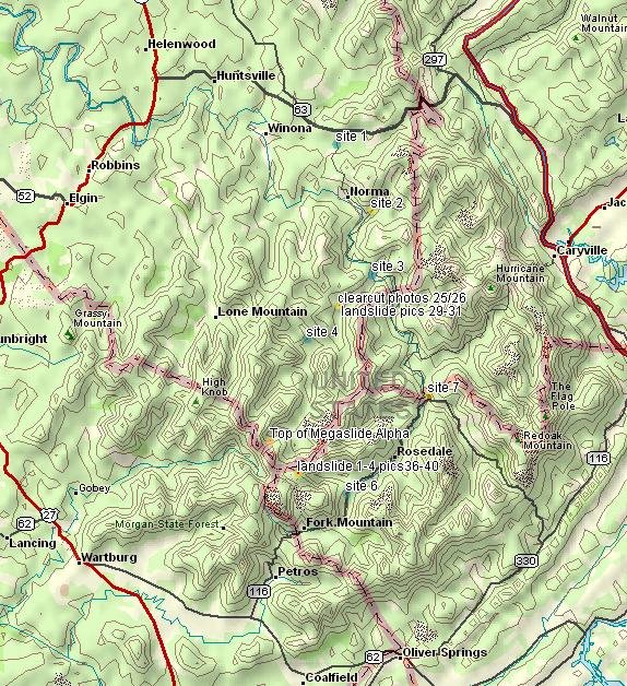 Above are the testing sites and where the pics where shot! Tap the map to enlarge it. This is new tech for us--next round we will be using larger text. We are working on a larger interactive map of the entire Cumberland coalfields in Tennessee.
TAP THIS TO VIEW STREAM TEST 1-7
NEW RIVER SCOUT MAR 25 2006
 THIS IS AT
BOTTOM OF JORDAN RIDGE AT THE BOTTOM OF THE RETAINING WALL. JORDAN RIDGE BELONGS TO NATIONAL COAL PERMIT # 3148
JORDAN RIDGE IS A REFUSE AREA WHERE THEY HAUL SPOIL FROM OTHER MINE SITES AND DUMP IT.
N 30 12.697
W 84 19.316
CHECK OUT THE NITRATE READING
DISSOLVED OXYGEN-3
PHOSPHATE- 0
**NITRATE-30
pH lAMOTTE- 7
pH sWIM KIT 7
MILAGE ON CAR 96.4
BOTTLE NUMBER 7
SITE NUMBER 7
NEW RIVER ROAD
NEW RIVER WATERSHED
NEAREST HOUSE DOWNSTREAM AT 1329
INDIAN FORK AND SLICK ROCK CREEK WATERSHEDS MARCH 25-2006.
 PIC 36
THIS IS THE SAME WATERSHED AS IN THE NATIONAL COAL SIGN BELOW.
N 36 09.722
W 84 25.460
MILE 68.9 ON TRUCK
NEW RIVER SCOUT MAR 25 2006
 PC 29
PC 29HIGHWALL EROSION
PICTURE TAKEN ON SMOKEY CREEK ROAD
N 36 11. 785
W 084 24.893

TOP OF MEGASLIDE ALPHA MAR 26 2006
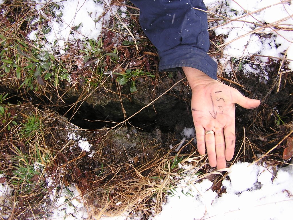 THIS CRACK IS 15 FEET FROM THE TOP EDGE OF MEGASLIDE ALPHA. 15 FEET OF MOUTAINTOP AT A TIME ARE CRACKING OFF AND SHOOTING DOWN THE WATERSHED. ICK. THIS IS THE TOP.
 MEGASLIDE ALPHA MARCH 25-2006

THIS IS FROM THE VERY TOP OF M.A. THIS IS THE GIS ON THE TOP CENTER OF M.A.
MEGASLIDE ALPHA MARCH 25-2006
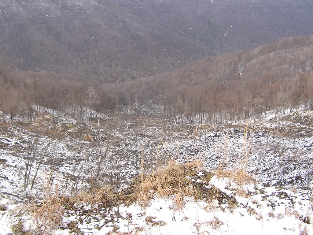 SHOT FROM ABOVE. THIS IS LOOKING STRAGHT DOWN FRO THE TOP OF MEGASLIDE ALPHA. THE ABOVE PIC IS FROM THE EXACT SAME LOCATION.
 MEGASLIDE ALPHA MARCH 25-2006
 AFFECTIONATELY KNOWN AS "MEGASLIDE ALPHA" THIS SLIDE HAS BECOME AN OLD FRIEND FOR OUR SCOUTS. WE HAVE TAKEN HIGH RESOLUTION PHOTO'S OF THIS SLIDE EVERY SEASON SINCE THE MAJOR SLIDE. HUGE AMOUNTS OF SOIL ARE BLOWING DOWN THE RIDGE.
GIS N 36 10.809 W 084 26 857
ELE 2737
NEW RIVER SCOUT MAR 25 2006
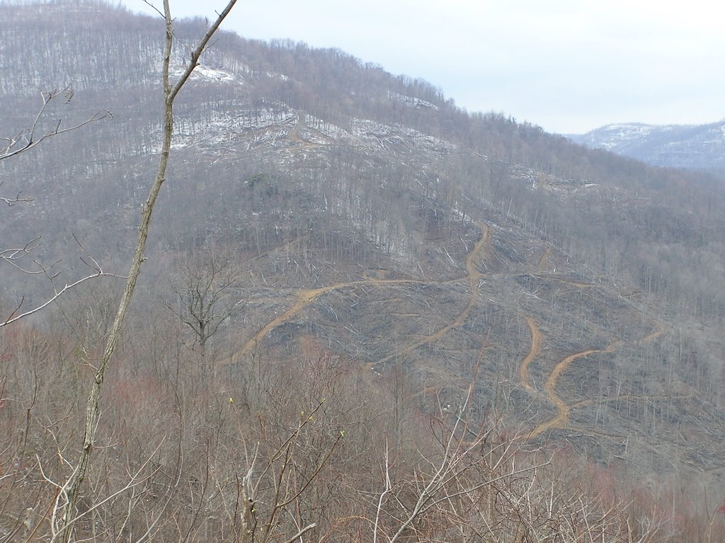
 THE NEW RIVER WATERSHED FROM HIGH POINT MOUNTAIN. WHY WE FIGHT FOR OUR MOUNTAINS!
LANDSLIDE MAR 25 2006
 BELOW IS A FROM THE ROAD A MILE DOWN FROM THIS SIGN. ITS ON THE OPPOSITE BANK FROM THIS SIGN, THE SAME WATERSHED. THE CREEKS LISTED ON THE SIGN HAVE THESE SLIDES ABOVE THEM. YOU CAN TOUCH THE PICTURE AND MAKE IT LARGER, THEN YOU CAN SEE THE GIS NUMBERS EASY..
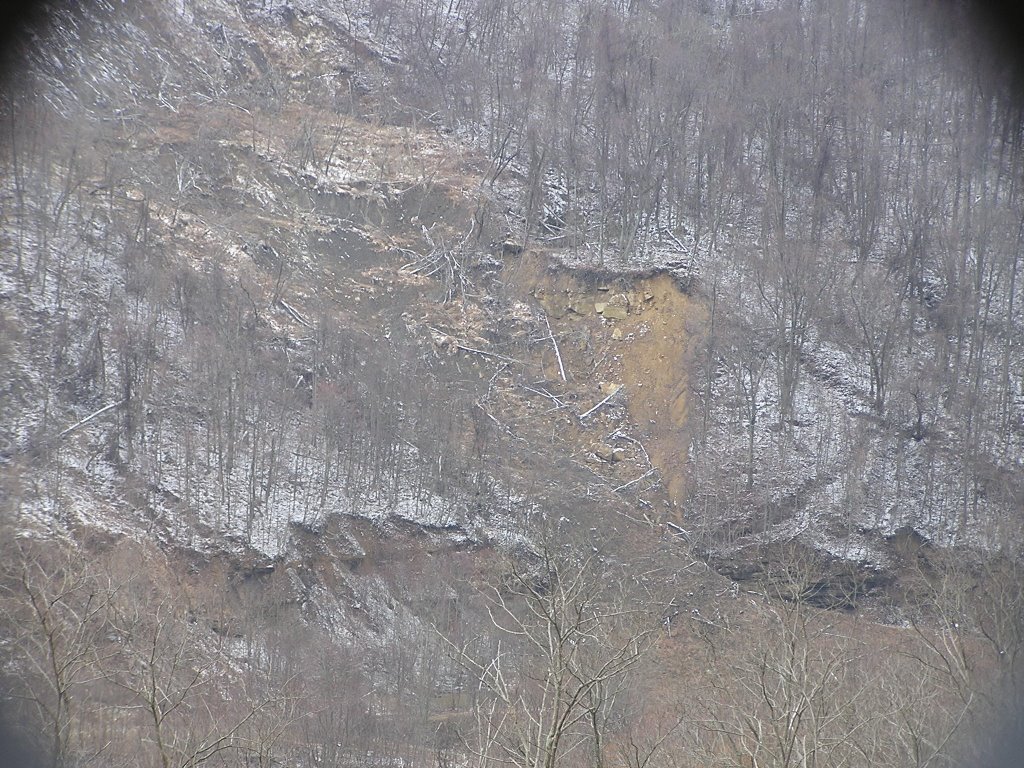 PIC 39 LANDSLIDE 2
WE SAW AND WENT TO ABOUT 7 LANDSLIDES ON THIS TRIP. WE GOT SOME OF THE SMALLER ONES AS WELL AS MORE OF MEGASLIDE ALPHA (OUR TERM).
THIS WAS SHOT WITH A TELEPHOTO LENSE. FROM ACROSS THE RIDGE.
GIS FROM WHERE STANDING N 36 09.722 W 84 25.460 UP FROM THE SIGN
THIS IS IN THE WATERSHED ON THE SIGN. IT IS ON THE OPPOSITE SIDE OF THE SIGN ABOVE THIS PICTURE--ON THE OPPOSITE RIDGE YOU ARE VIEWING ON THE OTHER SIDE OF THE RIDGE OF THIS SIGN. THERE ARE ALSO TWO LANDSLIDES BEHIND THE SIGN.
NEW RIVER SCOUT MAR 25 2006
 PIC NUMBER 32
THIS IS FROM STANDING AT GIS-N 36 11.785 W 084-24.893
CLEARCUT
THE NEW RIVER MARCH 25 2006
 THIS IS FROM THE ART LOWE BRIDGE AT SMOKEY JUNCTION. THIS STREAM IS USUALLY THIS BRIGHT GREEN.
PICTURE NUMBER 19
GIS N 36 17.228 W 084 22.020
APPEARANCE BRIGHT GREEN
PHOSPHATE-0
NITRATE- 0
OXYGEN- 3
pH SWIM KIT-7.5
pH LAMOTTE KIT-8.5
PIC 72 MARCH 26 2006
 BRIGHT ORANGE WATER AND WATERCOURSE
GIS N 36 08.957 W 084 23.199
NEW RIVER WATERSHED
CORNER OF NEW RIVER ROAD/BASE OF MASSIVE HOLLOW FILL. ACROSS FROM NATIONAL COAL PREP PLANT NUMBER 3 PERMIT NUMBER 3196
APPEARANCE OF THE STREAM--YOU CAN SEE FOR YOURSELF.
PH LAMOTTE KIT 8
pH SWIM KIT 7.5
DISSOLVED OXYGEN TEST 3
PHOSPHEROUS-0
NITRATE-0
UNITED MOUNTAIN DEFENSE TEST PICS
 SEE STREAM ABOVE. YES THE PERSON IS OUT OF FOCUS, BUT THE STREAM IS IN FOCUS WHICH IS WHERE THE FOCUS SHOULD BE.
As I suspected, that bottle with red (no. 6) tested very high for iron
(>2.5 ppm). I would estimate that this is at least 500-5,000 times
above the natural iron concentration for that area. I would guess this is
pyrite (Anakeesta-like stuff; iron sulfide) from the coal or related
deposits. Needless to say that level of iron is deadly to drink because
it bioaccumulates in living tissue and causes brain damage.
posted by Chris Irwin @ 10:33 AM
![]()

0 Comments:
Post a Comment
<< Home